
How was the land aquired to create the buffer zone around the AT? I know many residents who don't take kindly to the AT and the "taking of their land" and there seems to be some tension over how this happened.
Welcome to the AppalachianTrailCafe.net!
Take a moment and register and then join the conversation
Take a moment and register and then join the conversation
AT buffer zone
This site uses cookies. By continuing to browse this site, you are agreeing to our Cookie Policy.
-
-
Not sure if it was condemned and stolen under eminent domain laws...or if it was just out and out right stolen...either way....

pipsissewa wrote:
How was the land aquired to create the buffer zone around the AT? I know many residents who don't take kindly to the AT and the "taking of their land" and there seems to be some tension over how this happened.
thanks for the spellin lesson Mr. Lone Wolf
-
www.merriam-webster.com/dictionary/eminent%20domain
-
A good article:
http://articles.latimes.com/1997-03-09/news/mn-36391_1_appalachian-trail
"Since 1978, the National Park Service and the U.S. Forest Service have spent about $170 million to acquire about 145,600 acres along the 2,160 miles of the Appalachian Trail, which stretches from Maine to Georgia. Most landowners along the trail have sold their property willingly; however, about 10% of the landowners have refused government offers, said Donald King, chief of the National Park Service land-acquisition project office."
I think that is supposed to be 1968, when the Trails System Act was passed. -
Thanks for posting the article. My google search was very frustrating. And thanks to all for the spell check. It looks like the eminent domain was immanent.
-
:lol:
pipsissewa wrote:
Thanks for posting the article. My google search was very frustrating. And thanks to all for the spell check. It looks like the eminent domain was immanent. -
imminent
pipsissewa wrote:
Thanks for posting the article. My google search was very frustrating. And thanks to all for the spell check. It looks like the eminent domain was immanent. -

LoboSolo wrote:
imminentpipsissewa wrote:
Thanks for posting the article. My google search was very frustrating. And thanks to all for the spell check. It looks like the eminent domain was immanent.
Did you mean: imminent
I'm outta apples, here have some pie -
no wonder my google search was frustrating
-
pipsissewa wrote:
no wonder my google search was frustrating
Yeah, my spell check is horrible :whistle:
at least you were able to find goggle -
i found it on bingrocksNsocks wrote:
pipsissewa wrote:
no wonder my google search was frustrating
Yeah, my spell check is horrible :whistle:
at least you were able to find goggleits all good -

hikerboy wrote:
i found it on bingrocksNsocks wrote:
pipsissewa wrote:
no wonder my google search was frustrating
Yeah, my spell check is horrible :whistle:
at least you were able to find goggle
I binged it, all I keaped getting was this
what does it mean? -
hikerboy wrote:
i found it on bingrocksNsocks wrote:
pipsissewa wrote:
no wonder my google search was frustrating
Yeah, my spell check is horrible :whistle:
at least you were able to find goggle
You do know what BING stands for? if you are not sure you can Google it
-
bfayer wrote:
hikerboy wrote:
i found it on bingrocksNsocks wrote:
pipsissewa wrote:
no wonder my google search was frustrating
Yeah, my spell check is horrible :whistle:
at least you were able to find goggle
You do know what BING stands for? if you are not sure you can Google it
Urban Dictionary
1. Bing
Bing is basically a copy of Google. Just way fucking stupider.
Guy 1 : "Hey let's go search random shit on Bing!"
Guy 2 : "Dude fish Bing, I'm going to Google."
mark as favorite buy bing mugs & shirts
search engine bing google ask yahoo
by The Fishinq Word Master November 04, 2009 add a video
1108 up, 374 down -
Where's LSChanges Daily→ ♪♫♪♫♪♫♪♫ ♪♫♪♫♪♫ ← Don't blame me. It's That Lonesome Guitar.
-
:woohoo:

milkman wrote:
Where's LS -
LoboSolo wrote:
:woohoo:milkman wrote:
Where's LS
Okay, who is the loser.... I mean winner. Checking threads.Non hikers are about a psi shy of a legal ball. -
Regardless of how the land that bounds the AT was gotten, I can tell you that the corridor is pretty narrow in places. My wife and I are boundary monitors here in NY, doing our work in the area of Graymoor, and there are places you could throw a rock across the land that the trail passes through.
-
pipsissewa wrote:
How was the land aquired to create the buffer zone around the AT? I know many residents who don't take kindly to the AT and the "taking of their land" and there seems to be some tension over how this happened.
Around here where I live, families lost their land to both the AT and the Blue Ridge Parkway. Definately some hostility. -
The way they keep rerouting the FT around here, it'll prolly be going thru my backyard soon.
Sorry about the thread drift. Just saying. -
The first time we hike through the Cumberland Valley in PA I heard that many people there resented the trail because of the land issue. The last time we were there, years ago at this point, I heard that most people were happy to have the trail because it meant that there could be no building and development on those lands. Not living anyplace close to there I don't know how most people in that area really feel, just what I've heard.
-
Interesting thread! Check out the AT corridor in Maryland, or northern Virginia (eg. on Google maps,) and you can see just how narrow it is in places, totally hemmed in by civilization (malls, suburbs, factories, farms) on both sides.
I know one of the contested areas has been the trail between US 19 (Elk Park) and Laurel Falls. Hikers as far back as 1990 or earlier were warned of booby traps and hostile locals. The Barefoot Sisters journal (2001) cites a nasty incident on that road crossing, and the same rumors.
Other places that took decades of negotiations with greedy landowners -- the ridge over Killington and Pico ski areas, and the ridge over Saddleback ski area in Maine.
Some time in the 1990s the so-called "Cumberland road walk" was routed off roads and onto fields and hedgerows. I believe that's currently the stretch between Darlington shelter and Boiling Springs PA. Very narrow corridor there, too, obvious when you walk it.
Stuff like this is why I like throwing a bit of money at MATC and the Maine AT Land Trust once a year. -

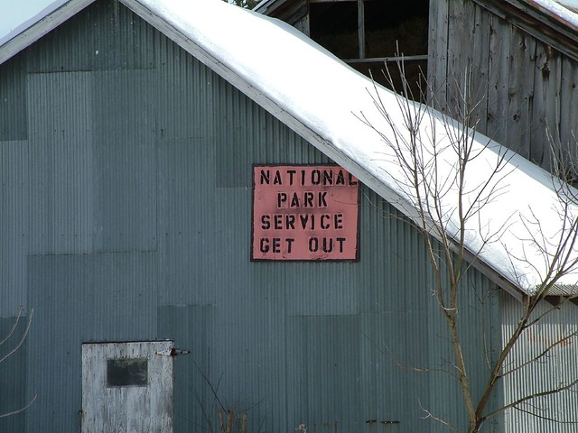
LIhikers wrote:
The first time we hike through the Cumberland Valley in PA I heard that many people there resented the trail because of the land issue. The last time we were there, years ago at this point, I heard that most people were happy to have the trail because it meant that there could be no building and development on those lands. Not living anyplace close to there I don't know how most people in that area really feel, just what I've heard.
In the area around DWG, some locals make their opinion known quite clearly:
[IMG:https://farm1.staticflickr.com/8/10605220_2766ddbd6a_z.jpg?zz=1]
0501300045 by steelmf, on FlickrI'm not lost. I know where I am. I'm right here. -
I wish the buffer was wider. I try to help conserve our nature by being a Sierra Club, ATC , and Grand Canyon Association member. I guess some of it is my guilty conscience for my job and what it does to the environment. I used to love what i do now i can't wait to retire from it."Dazed and Confused"
Recycle, re-use, re-purpose
Plant a tree
Take a kid hiking
Make a difference
-
Share
- Facebook 0
- Twitter 0
- Google Plus 0
- Reddit 0