Nice job, nice video - I wish I could watch an entire AT thru hike - well OK, not the sleeping or the privy stops.
I am human and I need to be loved - just like everybody else does

This site uses cookies. By continuing to browse this site, you are agreeing to our Cookie Policy.

CoachLou wrote:
As I understand it.....the south slope to the trail gets real wet and this entire area is mud when in a wet season. The original puncheon was sliding down hill and deteriorating. We put new stuff in, dug big enough holes for the support logs, to sit them in crushed stone. and stepped the path and made them level so you don't go for a ride when wet or icey.mental note wrote:
Nice job Lou! Perhaps it's obviously to some,but I don't know much about the why for's and how comes of trail design, what does that bridging do? I understand the swampy areas, but he areas up higher on the ridge. Enjoyed the video, I wanted to hike longer, thanks Brada.
We have some pretty talented folks on this crew, and they make sure we all know what where and why we are doing it.

WanderingStovie wrote:
Nice job, nice video - I wish I could watch an entire AT thru hike - well OK, not the sleeping or the privy stops.


Astro wrote:
Video doesn't cover every step, but it is the best I have ever seen of an AT Thru-Hike.

CoachLou wrote:
mental note wrote:
Nice job Lou! Perhaps it's obviously to some,but I don't know much about the why for's and how comes of trail design, what does that bridging do? I understand the swampy areas, but he areas up higher on the ridge. Enjoyed the video, I wanted to hike longer, thanks Brada.
As I understand it.....the south slope to the trail gets real wet and this entire area is mud when in a wet season. The original puncheon was sliding down hill and deteriorating. We put new stuff in, dug big enough holes for the support logs, to sit them in crushed stone. and stepped the path and made them level so you don't go for a ride when wet or icey.
We have some pretty talented folks on this crew, and they make sure we all know what where and why we are doing it.

AnotherKevin wrote:
The ones that astonish me are the ones on rafts, because there's no solid bottom anywhere for the footings.CoachLou wrote:
As I understand it.....the south slope to the trail gets real wet and this entire area is mud when in a wet season. The original puncheon was sliding down hill and deteriorating. We put new stuff in, dug big enough holes for the support logs, to sit them in crushed stone. and stepped the path and made them level so you don't go for a ride when wet or icey.mental note wrote:
Nice job Lou! Perhaps it's obviously to some,but I don't know much about the why for's and how comes of trail design, what does that bridging do? I understand the swampy areas, but he areas up higher on the ridge. Enjoyed the video, I wanted to hike longer, thanks Brada.
We have some pretty talented folks on this crew, and they make sure we all know what where and why we are doing it.
[IMG:https://c7.staticflickr.com/4/3950/15402044190_8ff1683782_z.jpg]
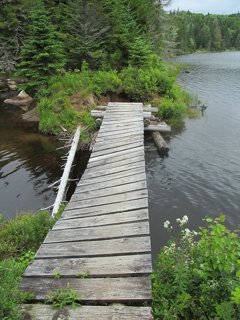
I really don't like the new ones of dimensioned lumber as well as the old-school puncheon bridges. The broadaxe cuts offered better traction. When the dimensioned planks get algae-covered, they get slippery, and a lot of them are not level. I remember one where I absolutely could not keep my footing, as soon as I tried to stand up on the tilted part, I slid right off again. I eventually managed to pass the tilted area by jamming my poles into the gaps between the planks and stepping on the uphill side of them. It was slow going. It would have been faster just to wade.
Only thing worse are the 'fun-house' bridges. Try crossing this one in heavy rain or sleet.
[IMG:https://c7.staticflickr.com/1/469/19585046462_a510960221_z.jpg]
And since mental note wants to hike longer, here's another couple of minutes of bog bridge:

CoachLou wrote:
Well, we were to open the work season this weekend, but the bosses went out yesterday to survey the work site and decided we have to postpone for a few weeks. With ALLLLLL the tools we have, we have no snow shovels!

CoachLou wrote:
Out on the trail again (...pictures...)
CoachLou wrote:
another weekend in New York, fixing the AT.
This time I camped up on a ledge on West Mtn., past the shelter on a ledge.
The proprietor met me and this is what greeted us in the morning
CoachLou wrote:
another weekend in New York, fixing the AT.
This time I camped up on a ledge on West Mtn., past the shelter on a ledge.
The proprietor met me and this is what greeted us in the morning
Big city, brite lights! And it never sleeps.NoAngel wrote:
I recognize that riffraff.CoachLou wrote:
another weekend in New York, fixing the AT.
This time I camped up on a ledge on West Mtn., past the shelter on a ledge.
The proprietor met me and this is what greeted us in the morning


LIhikers wrote:
I hate to admit it but Kathy and I haven't gotten out to do our boundary monitoring this spring.
And the way it looks, it will probably be August until we can get to it.
We also haven't gotten out for an overnighter in May and we'll probably miss June too.
I hate it when real life gets in the way of the things I enjoy.
CoachLou wrote:
....it is all good, you folks should get involved locally, it is very rewarding.
CoachLou wrote:
Made small rocks out of big rocks, Saturday. Climbed trees on Sunday to move the High Line!

PaulMags wrote:
Two days of trail maintenance on The Colorado Trail. The first day was a solid 16 mile hike with lots of blow down clearing. The second day was more of a mellow walk through with lopping and similar trimming.
The best part?
PaulMags wrote:
Quite a few of us did some trailwork on Segment 12 of the Collegiate East Saturday. A smaller group of us did some work on Segment 14 on Sunday. The Western portion looks snowy. The East is rather nice.


SarcasmTheElf wrote:
After reading that letter to the editor you wrote, I'd have thought that you would be working on NH trails.PaulMags wrote:
Quite a few of us did some trailwork on Segment 12 of the Collegiate East Saturday. A smaller group of us did some work on Segment 14 on Sunday. The Western portion looks snowy. The East is rather nice.
PaulMags wrote:
Well, apparently I've been backpacking since I was just born, have a husband, and a son, too. :OSarcasmTheElf wrote:
After reading that letter to the editor you wrote, I'd have thought that you would be working on NH trails.PaulMags wrote:
Quite a few of us did some trailwork on Segment 12 of the Collegiate East Saturday. A smaller group of us did some work on Segment 14 on Sunday. The Western portion looks snowy. The East is rather nice.
CoachLou wrote:
Another weekend workin'!
Rafe working hard and we had a special guest on Saturday
No just a thru that knew her. Ov and her daughter were at a civil war reinactment inMassachusettsTrafficJam wrote:
Cool! Is that OV giving Miss J a hug?
You know, now that I look, I have posted a picture or two of Ov in a teal shirt and black shorts!TrafficJam wrote:
Cool! Is that OV giving Miss J a hug?
If you enjoy bushwacking, you'd enjoy doing this. 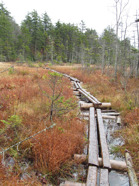