
Green Mountain Club Updates on the Vermont flooding damage
July 2023 Flood
On July 10, 2023 Vermont experienced historic rainfall and widespread flooding. 24-hour rainfall totals ranged from 3-7+ inches, with the highest totals concentrated along the spine of the Green Mountains. The Winooski River flooded over in several places, and many mountain communities experienced widespread flooding and damage. Here we compile trail updates from the July 2023 flood.
GMC pulled all field staff (caretakers and trail crews) from the field beginning on Sunday, July 9, in anticipation of the weather event. On Wednesday and Thursday, July 12-13, crews conducted a rapid trail assessment to determine road and trailhead access in popular areas and baseline bridge inspection. A full account of conditions and damage to the Long Trail System will take some time.
For those looking to support flood relief efforts in affected communities, here are some ways you can help.
Friday, July 14: GMC Crews have completed an initial rapid assessment of road and trailhead access, bridges, and high-use portions of trail. Our initial findings are quite positive: no major infrastructure was compromised and while there is on-trail damage, nothing that indicates a major threat to hiker safety or trail continuity. The below closures remain in place, and hikers are urged to use extreme caution and judgement if heading out in the woods. Emergency resources statewide remain taxed, and many trailside communities are grappling with destruction of their homes, businesses, and livelihoods. GMC Backcountry caretakers are beginning to return to their sites, but the full contingency of field staff will be up and running starting next week. More information from GMC, including how to volunteer in our recovery efforts, is forthcoming. Thank you all for your ongoing prudence and support.
Trail Updates from Vermont 2023 Flood
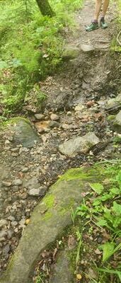
[IMG:https://www.greenmountainclub.org/wp-content/uploads/2023/07/Long-Trail-Erosion_Washout_VT-11-to-VT-103_July-2023-Flood-Aftermath-rotated.jpeg]Trail Erosion and Washout in the Peru Peak – Little Rock Pond stretch of the LT/AT
Trail, Shelter, and Bridge Closure Updates as of 1 p.m., Sunday, July 16, 2023
July 2023 Flood
On July 10, 2023 Vermont experienced historic rainfall and widespread flooding. 24-hour rainfall totals ranged from 3-7+ inches, with the highest totals concentrated along the spine of the Green Mountains. The Winooski River flooded over in several places, and many mountain communities experienced widespread flooding and damage. Here we compile trail updates from the July 2023 flood.
GMC pulled all field staff (caretakers and trail crews) from the field beginning on Sunday, July 9, in anticipation of the weather event. On Wednesday and Thursday, July 12-13, crews conducted a rapid trail assessment to determine road and trailhead access in popular areas and baseline bridge inspection. A full account of conditions and damage to the Long Trail System will take some time.
For those looking to support flood relief efforts in affected communities, here are some ways you can help.
Friday, July 14: GMC Crews have completed an initial rapid assessment of road and trailhead access, bridges, and high-use portions of trail. Our initial findings are quite positive: no major infrastructure was compromised and while there is on-trail damage, nothing that indicates a major threat to hiker safety or trail continuity. The below closures remain in place, and hikers are urged to use extreme caution and judgement if heading out in the woods. Emergency resources statewide remain taxed, and many trailside communities are grappling with destruction of their homes, businesses, and livelihoods. GMC Backcountry caretakers are beginning to return to their sites, but the full contingency of field staff will be up and running starting next week. More information from GMC, including how to volunteer in our recovery efforts, is forthcoming. Thank you all for your ongoing prudence and support.
Trail Updates from Vermont 2023 Flood
[IMG:https://www.greenmountainclub.org/wp-content/uploads/2023/07/Long-Trail-Erosion_Washout_VT-11-to-VT-103_July-2023-Flood-Aftermath-rotated.jpeg]Trail Erosion and Washout in the Peru Peak – Little Rock Pond stretch of the LT/AT
Trail, Shelter, and Bridge Closure Updates as of 1 p.m., Sunday, July 16, 2023
- Bamforth Ridge shelter is closed. The foundation is structurally unsound due to rainfall damage. There are a few tent platforms at the site, and Montclair Glen is 5.5 miles to the south, and Buchanan Shelter is 12 miles north.
- The Long Trail through the Winooski Valley farm fields (between Bamforth Ridge and the Winooski River footbridge) is closed. The trail is flooded and contains numerous live electric fence wires. You can road walk around the fields.
- The Lamoille River suspension bridge is closed due to continued flooding conditions. The highwater bypass road walk is open.
- Peru Peak Shelter bridge (just north of the shelter) has a temporary walk-around established while further assessment is completed to determine if the bridge needs permanent closure.
- The Forest City Trail bridge is closed.
- The Gulf Stream bridge on the Appalachian Trail at Route 12 has an extremely washed out approach, but the bridge structure remains safe and passable. Do not attempt to ford the stream.
- Road access (Gilman Road) to Governor Clement Shelter is closed.
- Forest Road 10 is closed to through traffic due to a previous washout. The LT/AT trailhead is accessible from the west.
- Kelley Stand Road is currently partially open, is down to one lane of traffic in spots.
- Cold River Road LT/AT is closed from the west side.
- County Road in Stamford is impassable. You can reach the LT/AT trailhead there via Klondike Road from North Adams (medium clearance necessary)
- FR-10 east of FR-30 is closed for bridge/culvert work that is scheduled to last for the rest of the summer. Combined with the previous washout, this eliminates road access to the Old Job Trailhead via FR-30.
“Of all sad words of tongue or pen,
the saddest are these, 'It might have been.”
John Greenleaf Whittier
the saddest are these, 'It might have been.”
John Greenleaf Whittier


