I suppose I should post one on topic post before I head out.
Non hikers are about a psi shy of a legal ball.

This site uses cookies. By continuing to browse this site, you are agreeing to our Cookie Policy.

BirdBrain wrote:
Hey ATM, I made some progress over here:
Sawyer Squeeze
Just helping you find it. I expected a comment last night. I saw you looking at it. It is rev 1 of the mini system. It will likely be improved... especially if people criticize it.

BirdBrain wrote:
hikerboy wrote:
BirdBrain wrote:
Hey ATM, I made some progress over here:
Sawyer Squeeze
Just helping you find it. I expected a comment last night. I saw you looking at it. It is rev 1 of the mini system. It will likely be improved... especially if people criticize it.
how do you use the sawyer squeeze to navigate?
I hang it from a tree. Mark where the bottom of the shadow strikes the ground. Wait 15 minutes and make another mark. This gives you the east west line. Bisect that line and you have north south. Carefully dig up your creation and carry it on a flat surface as you hike out.


AnotherKevin wrote:
It makes perfect sense, but I do occasionally teach this stuff.
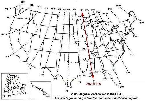
Usually you will use EITHER the arithmetic sign OR the word 'East' or 'West', not both. Tennessee, like all the rest of Appalachia, does indeed have a westward declination, so your compass will point west of true north. The agonic line, or nullcline, runs nearly down the Mississippi River. Thunder Bay, the Quad Cities, St. Louis, Memphis and Biloxi all have declination that is close to zero.
[IMG:http://www.summitpost.org/images/medium/358202.jpg]
If you have a direction measured from a line of longitude on a map, that's a true direction. It's measured clockwise from north, so east is 90°, south is 180°, west is 270°.
To make a true direction into a compass direction, the mnemonic is:
Timid Virgins Make Dull Company At Weddings
which is:
- take the True direction
- adjust for Variation (your 5.5°)
- gives a Magnetic direction
- adjust for Deviation (zero for a handheld compass, but will be significant in a vehicle, ship, or aircraft and must be measured.
- gives a Compass direction
- Add West - which means add if the variation or deviation is West, subtract if it's East.
So if you measure, say, 45° on a map, True (45°) + (Add West) Variation (5.5°) = Magnetic (50.5°). Your magnetic heading would be 50.5° (and for a handheld compass clear of metal objects, the deviation will be negligible, so your compass heading will be negligible as well).
To go the other way, for instance if you've taken a compass sight and want to draw it on the map, the rule is:
Chicago Dead Men Vote Twice At Elections
which is:
If either procedure gives a negative number or a number greater than 360°, add or subtract 360°. So if you measured a heading of 3° in the field:
- take the Compass heading
- adjust for Deviation (again, negligible for a handheld compass in the field)
- gives a Magnetic direction
- adjust for Variation (your 5.5°)
- gives the True direction
- Add East - add if the variation or deviation is East, subtract if it's West
Compass (3°) - (Add East, and the variation is West) Variation (5.5°) = True (-1.5°). This is less than 360°, so add 360° to get 358.5°.
I recommend that newbies get a compass with an adjustable declination[1] (this has become a cheap feature, so a lot of compasses have it), adjust it to the area where they intend to hike, and then work with True directions throughout, changing only when they're hiking outside their home turf. We do well in the field to sight within a degree or two of error, so even the map above will give a reasonable idea of the figure to use. Then, as long as you're using an adjustable compass, there's no worry about getting the arithmetic right, which can be particularly challenging if you're disoriented, the weather is bad, and you're tired - just the conditions you're likely to be under when you're trying to become un-lost. So, for example, living near Albany, New York, I just leave my compass set on 14° West. That' setting is Close Enough for the Adirondacks, the Catskills, and anywhere along the AT from Delaware Water Gap to Maine Junction. I pretty much never hike outside that area at the moment. I'll have to remember to reset it if I ever travel down your way.
The classes that ADK offers teach this method, and for ADK trips in winter or off trail, the participants are required to have an adjustable-declination compass unless they can demonstrate that they're already proficient in another method.
An alternative, that a lot of teachers prefer, is to work in magnetic directions throughout. This is easier if, when you first get a map, you lay it out, take a long straightedge, and scribe lines a couple of inches apart all over it that run magnetic north and south. When you are plotting a direction on the map, you can lay your protractor along one of these lines. Pilots are taught this method, and things like airport runway headings and directions from navigational aids are all quoted as magnetic directions. I like this less well because you have to prepare every map, rather than preparing your compass once.
I'm comfortable with all three methods (adjustable compass, scribed map, arithmetic), but I think the method of using an adjustable compass and working in true directions is the one that I'm least likely to screw up in a bad situation when I'm addled.
= = = = =
[1] I mean an actual compass with a swinging magnet in it. What's the battery life on your compass watch? How repeatable are its measurements? Does its variation change depending on what other functions of the watch are active? And (most important to me) how do you sight it? If all you care is, "is the trail I'm on heading in approximately the right direction," then you don't even need to worry about compass variation. If you're depending on a compass enough to need the variation set, then you need one you can sight accurately.
The post was edited 1 time, last by Traffic Jam ().


max.patch wrote:
AK, lets pretend for a moment that the whites don't exist.
as a practical matter, if you were to get lost on the AT, can you ignore declination as you figure out how to get back to the trail/civilization?
my guess is that you can, but i've never been lost so i haven't been able to test my theory.
AnotherKevin wrote:
It makes perfect sense, but I do occasionally teach this stuff.
Usually you will use EITHER the arithmetic sign OR the word 'East' or 'West', not both. Tennessee, like all the rest of Appalachia, does indeed have a westward declination, so your compass will point west of true north. The agonic line, or nullcline, runs nearly down the Mississippi River. Thunder Bay, the Quad Cities, St. Louis, Memphis and Biloxi all have declination that is close to zero.
[IMG:http://www.summitpost.org/images/medium/358202.jpg]
If you have a direction measured from a line of longitude on a map, that's a true direction. It's measured clockwise from north, so east is 90°, south is 180°, west is 270°.
To make a true direction into a compass direction, the mnemonic is:
Timid Virgins Make Dull Company At Weddings
which is:
- take the True direction
- adjust for Variation (your 5.5°)
- gives a Magnetic direction
- adjust for Deviation (zero for a handheld compass, but will be significant in a vehicle, ship, or aircraft and must be measured.
- gives a Compass direction
- Add West - which means add if the variation or deviation is West, subtract if it's East.
So if you measure, say, 45° on a map, True (45°) + (Add West) Variation (5.5°) = Magnetic (50.5°). Your magnetic heading would be 50.5° (and for a handheld compass clear of metal objects, the deviation will be negligible, so your compass heading will be negligible as well).
To go the other way, for instance if you've taken a compass sight and want to draw it on the map, the rule is:
Chicago Dead Men Vote Twice At Elections
which is:
If either procedure gives a negative number or a number greater than 360°, add or subtract 360°. So if you measured a heading of 3° in the field:
- take the Compass heading
- adjust for Deviation (again, negligible for a handheld compass in the field)
- gives a Magnetic direction
- adjust for Variation (your 5.5°)
- gives the True direction
- Add East - add if the variation or deviation is East, subtract if it's West
Compass (3°) - (Add East, and the variation is West) Variation (5.5°) = True (-1.5°). This is less than 360°, so add 360° to get 358.5°.
I recommend that newbies get a compass with an adjustable declination[1] (this has become a cheap feature, so a lot of compasses have it), adjust it to the area where they intend to hike, and then work with True directions throughout, changing only when they're hiking outside their home turf. We do well in the field to sight within a degree or two of error, so even the map above will give a reasonable idea of the figure to use. Then, as long as you're using an adjustable compass, there's no worry about getting the arithmetic right, which can be particularly challenging if you're disoriented, the weather is bad, and you're tired - just the conditions you're likely to be under when you're trying to become un-lost. So, for example, living near Albany, New York, I just leave my compass set on 14° West. That' setting is Close Enough for the Adirondacks, the Catskills, and anywhere along the AT from Delaware Water Gap to Maine Junction. I pretty much never hike outside that area at the moment. I'll have to remember to reset it if I ever travel down your way.
The classes that ADK offers teach this method, and for ADK trips in winter or off trail, the participants are required to have an adjustable-declination compass unless they can demonstrate that they're already proficient in another method.
An alternative, that a lot of teachers prefer, is to work in magnetic directions throughout. This is easier if, when you first get a map, you lay it out, take a long straightedge, and scribe lines a couple of inches apart all over it that run magnetic north and south. When you are plotting a direction on the map, you can lay your protractor along one of these lines. Pilots are taught this method, and things like airport runway headings and directions from navigational aids are all quoted as magnetic directions. I like this less well because you have to prepare every map, rather than preparing your compass once.
I'm comfortable with all three methods (adjustable compass, scribed map, arithmetic), but I think the method of using an adjustable compass and working in true directions is the one that I'm least likely to screw up in a bad situation when I'm addled.
= = = = =
[1] I mean an actual compass with a swinging magnet in it. What's the battery life on your compass watch? How repeatable are its measurements? Does its variation change depending on what other functions of the watch are active? And (most important to me) how do you sight it? If all you care is, "is the trail I'm on heading in approximately the right direction," then you don't even need to worry about compass variation. If you're depending on a compass enough to need the variation set, then you need one you can sight accurately.
TrafficJam wrote:
Thank you! I understand most of this but will have to think about the math a little more. Based on your explanation, I believe that the declination on my watch should be set to "East 5.50"
Question... Is the Agonal line also called "The Meridian Line" or is it one of the 12 main meridian lines?
My watch has a digital compass with a magnetic North indicator and a bearing indicator that can be locked in place. It displays the heading in degrees and cardinals. The battery life is 14 days in Time mode, or 10/15/100 hrs in GPS mode depending on accuracy. I don't understand the question about the repeatable measurements (?). I don't think the variation changes when other functions are being used...the compass is always accessible when using other functions.
I will mainly use it to supplement maps to ensure I'm heading in the right direction...it will never be a primary means of navigation (but I still like knowing how this stuff works.)

LIhikers wrote:
I used to know how to use a compass and map.......then I read Kevin's explanation.
Now I'm confused
LIhikers wrote:
I used to know how to use a compass and map.......then I read Kevin's explanation.
Now I'm confused
AnotherKevin wrote:
I shouldn't describe three methods for compass variation in the same post. Sorry.LIhikers wrote:
I used to know how to use a compass and map.......then I read Kevin's explanation.
Now I'm confused
If you're a boundary monitor, your orienteering skills are already better than the vast majority of hikers. And I'm sure you're already familiar with one of the methods. So carry on.

LIhikers wrote:
Actually my compass skills come from when I got my pilot license.Beside everything you mentioned, I had to compensate for the wind too.AnotherKevin wrote:
I shouldn't describe three methods for compass variation in the same post. Sorry.If you're a boundary monitor, your orienteering skills are already better than the vast majority of hikers. And I'm sure you're already familiar with one of the methods. So carry on.LIhikers wrote:
I used to know how to use a compass and map.......then I read Kevin's explanation.
Now I'm confused

JimBlue wrote:
Another example: our radio navigation went out coming back from the Mediterranean Sea.
chief wrote:
Was that the same ship you lost radio communications, 3 of 4 boilers and 1 of 2 turbines and was hit by hurricane Camille?JimBlue wrote:
Another example: our radio navigation went out coming back from the Mediterranean Sea.

AnotherKevin wrote:
And I'm guessing that you're old enough that you figured the wind triangle on an E6B whiz-wheel.LIhikers wrote:
Actually my compass skills come from when I got my pilot license.Beside everything you mentioned, I had to compensate for the wind too.AnotherKevin wrote:
I shouldn't describe three methods for compass variation in the same post. Sorry.If you're a boundary monitor, your orienteering skills are already better than the vast majority of hikers. And I'm sure you're already familiar with one of the methods. So carry on.LIhikers wrote:
I used to know how to use a compass and map.......then I read Kevin's explanation.
Now I'm confused

CoachLou wrote:
Your compass and Deet should never be stored in the same pocket

Drybones wrote:
I'm a visual learner...that map tells it all...thanks.AnotherKevin wrote:
It makes perfect sense, but I do occasionally teach this stuff.
Usually you will use EITHER the arithmetic sign OR the word 'East' or 'West', not both. Tennessee, like all the rest of Appalachia, does indeed have a westward declination, so your compass will point west of true north. The agonic line, or nullcline, runs nearly down the Mississippi River. Thunder Bay, the Quad Cities, St. Louis, Memphis and Biloxi all have declination that is close to zero.
[IMG:http://www.summitpost.org/images/medium/358202.jpg]
If you have a direction measured from a line of longitude on a map, that's a true direction. It's measured clockwise from north, so east is 90°, south is 180°, west is 270°.
To make a true direction into a compass direction, the mnemonic is:
Timid Virgins Make Dull Company At Weddings
which is:
- take the True direction
- adjust for Variation (your 5.5°)
- gives a Magnetic direction
- adjust for Deviation (zero for a handheld compass, but will be significant in a vehicle, ship, or aircraft and must be measured.
- gives a Compass direction
- Add West - which means add if the variation or deviation is West, subtract if it's East.
So if you measure, say, 45° on a map, True (45°) + (Add West) Variation (5.5°) = Magnetic (50.5°). Your magnetic heading would be 50.5° (and for a handheld compass clear of metal objects, the deviation will be negligible, so your compass heading will be negligible as well).
To go the other way, for instance if you've taken a compass sight and want to draw it on the map, the rule is:
Chicago Dead Men Vote Twice At Elections
which is:
If either procedure gives a negative number or a number greater than 360°, add or subtract 360°. So if you measured a heading of 3° in the field:
- take the Compass heading
- adjust for Deviation (again, negligible for a handheld compass in the field)
- gives a Magnetic direction
- adjust for Variation (your 5.5°)
- gives the True direction
- Add East - add if the variation or deviation is East, subtract if it's West
Compass (3°) - (Add East, and the variation is West) Variation (5.5°) = True (-1.5°). This is less than 360°, so add 360° to get 358.5°.
I recommend that newbies get a compass with an adjustable declination[1] (this has become a cheap feature, so a lot of compasses have it), adjust it to the area where they intend to hike, and then work with True directions throughout, changing only when they're hiking outside their home turf. We do well in the field to sight within a degree or two of error, so even the map above will give a reasonable idea of the figure to use. Then, as long as you're using an adjustable compass, there's no worry about getting the arithmetic right, which can be particularly challenging if you're disoriented, the weather is bad, and you're tired - just the conditions you're likely to be under when you're trying to become un-lost. So, for example, living near Albany, New York, I just leave my compass set on 14° West. That' setting is Close Enough for the Adirondacks, the Catskills, and anywhere along the AT from Delaware Water Gap to Maine Junction. I pretty much never hike outside that area at the moment. I'll have to remember to reset it if I ever travel down your way.
The classes that ADK offers teach this method, and for ADK trips in winter or off trail, the participants are required to have an adjustable-declination compass unless they can demonstrate that they're already proficient in another method.
An alternative, that a lot of teachers prefer, is to work in magnetic directions throughout. This is easier if, when you first get a map, you lay it out, take a long straightedge, and scribe lines a couple of inches apart all over it that run magnetic north and south. When you are plotting a direction on the map, you can lay your protractor along one of these lines. Pilots are taught this method, and things like airport runway headings and directions from navigational aids are all quoted as magnetic directions. I like this less well because you have to prepare every map, rather than preparing your compass once.
I'm comfortable with all three methods (adjustable compass, scribed map, arithmetic), but I think the method of using an adjustable compass and working in true directions is the one that I'm least likely to screw up in a bad situation when I'm addled.
= = = = =
[1] I mean an actual compass with a swinging magnet in it. What's the battery life on your compass watch? How repeatable are its measurements? Does its variation change depending on what other functions of the watch are active? And (most important to me) how do you sight it? If all you care is, "is the trail I'm on heading in approximately the right direction," then you don't even need to worry about compass variation. If you're depending on a compass enough to need the variation set, then you need one you can sight accurately.
Gah! I thought I understood but still confused...I thought it was obvious that it is East 5.50*, why West? Because the needle is pulled to the west? If East is negative and my declination is negative why isn't it East?mental note wrote:
TJ you explained that perfectly. I always remember it like this "East is least West is best" but acknowledge that that wasn't really your question, (Kelvin nails it in fine fashion and form...beautifully and eloquently text book like) I always have to take a moment too to figure out just exactly what it means in a practical means as well, which is why I like to carry a compass a bone up on map skills in the first place on outings cause that's to only practice I really give myself...which is not nearly enough to my likin'
I'm sorry but now I'm confused, does it say in your specs of the watch that it corrects for declination? I can't see how it wouldn't allow for the negative.TrafficJam wrote:
Gah! I thought I understood but still confused...I thought it was obvious that it is East 5.50*, why West? Because the needle is pulled to the west? If East is negative and my declination is negative why isn't it East?mental note wrote:
TJ you explained that perfectly. I always remember it like this "East is least West is best" but acknowledge that that wasn't really your question, (Kelvin nails it in fine fashion and form...beautifully and eloquently text book like) I always have to take a moment too to figure out just exactly what it means in a practical means as well, which is why I like to carry a compass a bone up on map skills in the first place on outings cause that's to only practice I really give myself...which is not nearly enough to my likin'
Good catch on KY!
perhaps...music is like that for me, it makes no sense and I just have to to take it for what it is and the rules that govern, kinda like organic chemistry...it is what it is.TrafficJam wrote:
Math has always been difficult for me because I want to know WHY you're supposed to do what you do...like there's some philosophical or theoretical guide that if I only understand, I can figure out the answers to problems.
Maybe I'm trying too hard to understand and just need to accept.
chief wrote:
Was that the same ship you lost radio communications, 3 of 4 boilers and 1 of 2 turbines and was hit by hurricane Camille?JimBlue wrote:
Another example: our radio navigation went out coming back from the Mediterranean Sea.
LIhikers wrote:
There are different kinds of compasses.
When Kathy and I started doing the boundary work along the AT we were instructed to get a quadrant compass.
That's because the maps that we got give heading from one surveyor's monument to the next in quadrant notation.
On that type of compass the face is marked with North and South as 0 and East and West as 90 degrees.
A heading might be,North 15 degrees West. That equates to 350 degrees as you and I know it.
We never bought the compass but just used simple arithmetic to convert and used our regular compass.
We're pretty familiar with where "our" monuments are by now and don't even bring a compass with us.
Yes, I have to set the declination for my location. I googled the declination for Knoxville and couldn't figure out how to put it in the format that is required on the watch. To tell you exactly what it says will tell everyone where I'm at right now which makes me uncomfortable but this may give you an idea...mental note wrote:
I'm sorry but now I'm confused, does it say in your specs of the watch that it corrects for declination? I can't see how it wouldn't allow for the negative.TrafficJam wrote:
Gah! I thought I understood but still confused...I thought it was obvious that it is East 5.50*, why West? Because the needle is pulled to the west? If East is negative and my declination is negative why isn't it East?Good catch on KY!mental note wrote:
TJ you explained that perfectly. I always remember it like this "East is least West is best" but acknowledge that that wasn't really your question, (Kelvin nails it in fine fashion and form...beautifully and eloquently text book like) I always have to take a moment too to figure out just exactly what it means in a practical means as well, which is why I like to carry a compass a bone up on map skills in the first place on outings cause that's to only practice I really give myself...which is not nearly enough to my likin'

TJ; Math is a skill based upon real world requirements. Each advancement in mathametics was generated in answer to a need someone recognized. Therefore your need to grasp the 'why' is valid.mental note wrote:
perhaps...music is like that for me, it makes no sense and I just have to to take it for what it is and the rules that govern, kinda like organic chemistry...it is what it is.TrafficJam wrote:
Math has always been difficult for me because I want to know WHY you're supposed to do what you do...like there's some philosophical or theoretical guide that if I only understand, I can figure out the answers to problems.
Maybe I'm trying too hard to understand and just need to accept
Declination means "turning."TrafficJam wrote:
Gah! I thought I understood but still confused...I thought it was obvious that it is East 5.50*, why West? Because the needle is pulled to the west? If East is negative and my declination is negative why isn't it East?

