Hateful......
Looks like a great time was had, D! Tell Mama I said hello!
Looks like a great time was had, D! Tell Mama I said hello!
If your Doctor is a tree, you're on acid.

This site uses cookies. By continuing to browse this site, you are agreeing to our Cookie Policy.

JimBlue wrote:
I think the only things in both instances of stomach upset, again this past Saturday, was the Clif bars I ate. One of my siblings pointed out she had problems after eating them to. So I guess I'll just hand them out the next time I go camping to other campers. At least I didn't buy a case of them, just a small box. Taste good, but I may as well eat green apples if I eat a Clif bar.

jimmyjam wrote:
most cliff bars taste like dirt+oatmeal+honey. I just eat breakfast bars and snickers, cheaper too.
JimBlue wrote:
I think the only things in both instances of stomach upset, again this past Saturday, was the Clif bars I ate. One of my siblings pointed out she had problems after eating them to. So I guess I'll just hand them out the next time I go camping to other campers. At least I didn't buy a case of them, just a small box. Taste good, but I may as well eat green apples if I eat a Clif bar.

AnotherKevin wrote:
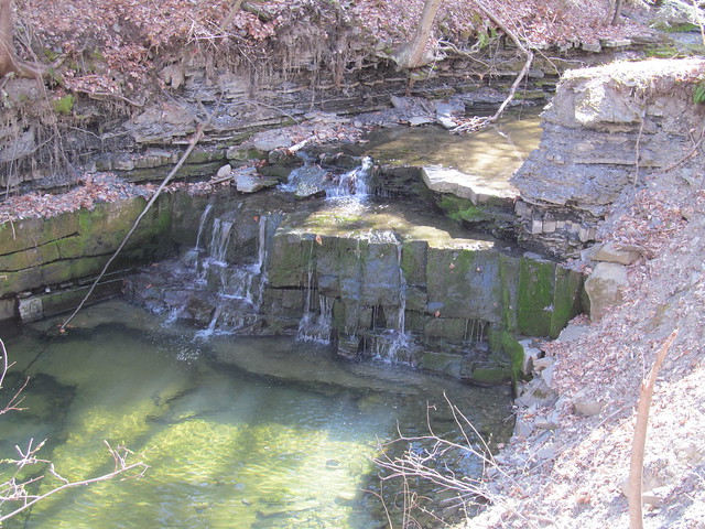
Took a walk yesterday to the Wolf Creek Falls Preserve in Knox, NY. Five miles of easy trail and my foot was killing me at the end, but I needed to get out for a few hours! This getting old stuff is the pits!
Trip report is here. The place has some interesting archaeology to it. And now Open Street Map has it, so lots of road maps and what-not will start to show it.
[IMG:https://farm2.staticflickr.com/1652/26649153735_fc0ca46b8f_z.jpg]
Wolf Creek Falls by Kevin Kenny, on FlickWreckage by Kevin Kenny, on Flickr
It's a stop on the New York Long Path.


AnotherKevin wrote:
Yeah, I'm on Long Island right now, and several Thruway exits had signs up about Minnewaska being closed on account of it. Even this many years later, the place is a tinderbox from all the debris from Irene. We're going to keep having fires every spring until all that stuff either burns or rots.

LIhikers wrote:
Kathy and I climbed into the car about 6AM this past Monday armed with a variety of trail maps for northern New Jersey, Hudson Valley, and Harriman State Park. As we drove toward the bridge, to get off Long Island, we decided to go to Harriman because it would be the least amount of driving. We parked at the Ramapo Equestrian Center and were walking by 8:15.We headed up the Pine Meadow trail to the Suffern Bear Mountain trail and turned south. Around 10AM we stopped to make breakfast and to take a break. The day was mostly overcast and a little too warm for how I dressed, so off came the vest.Continuing south we came to a rocky view point around noon and stopped for lunch. After eating my PBJ sandwich I lay down on the rock, in the bright sun, and spent some time catching up on my lack of sleep. When I finally woke up we continued on over a series of trails that eventually took us back toward Pine Meadow Lake. We walked most of the length of the lake and came across a beautiful spot where it was obvious that many people had camped over time. We set up camp and relaxed by the lake shore before having dinner made over out MSR Simmerlite stove, in our K-Mart grease pot. We ate as the sun sank lower and lower toward the horizon. Eventually we climbed into our tent, a Tarptent Rainshadow II, and chatted and slowly slipped into the relaxation of sleep. Then, some time in the middle of the night, thunder cracked and lightening flashed across the sky and then the heavens opened and rain poured down. Our dog was scared by the thunder and lightening and crawled up between me and Kathy and spent the night shivering in fear. I fell back asleep despite the sky show and finally woke up well after morning. The rain had stopped and we got up and had breakfast and packed up. After looking at the map we decided to hike back toward the car on unmarked trails and woods roads. The day brought us heavy fog with almost no visibility. At one point we were unsure of which way to go at an intersection of trails because the lay out of the trails didn’t look the same as on the map. After a ways we didn’t think the trail was taking us in the right direction and I broke out my compass to check. Sure enough we were headed back into the park instead of toward our car. So we changed direction and went the right way once we got back to the intersection. Our hike continued and got us back to our car just as the rain started to come down hard again. The trip was short but it gave us a chance for relaxation and enjoyment that we get from being in the woods.


How many pounds did you drink?TrafficJam wrote:
Took a little walk on the local greenway. Wore my daypack with 12lbs of water bottles (thanks for the tip, Sandy). That was a great workout and prep for my upcoming trip.

LIhikers wrote:
. After eating my PBJ sandwich I lay down on the rock, in the bright sun, and spent some time catching up on my lack of sleep.

Trebor wrote:
Took a long drive and a short walk to my favorite fishing spot on Friday. Weather was perfect.
LIhikers wrote:
I don't have the patients for fishing, besides, the fish always win.Trebor wrote:
Took a long drive and a short walk to my favorite fishing spot on Friday. Weather was perfect.
LIhikers wrote:
I don't have the patients for fishing, besides, the fish always win.Trebor wrote:
Took a long drive and a short walk to my favorite fishing spot on Friday. Weather was perfect.

Trebor wrote:
Took a long drive and a short walk to my favorite fishing spot on Friday. Weather was perfect.

CoachLou wrote:
I just got an Email, we are not going to Minnewaska until they are out. They will start a project on Black Mtn./AT, in Harriman,on the west side of the Palisade Parkway. That will take us into the summer.AnotherKevin wrote:
Yeah, I'm on Long Island right now, and several Thruway exits had signs up about Minnewaska being closed on account of it. Even this many years later, the place is a tinderbox from all the debris from Irene. We're going to keep having fires every spring until all that stuff either burns or rots.

Trillium wrote:
Every single time that you Yankees mention Harriman Park, I am transported back to my high school days and think first of that railroad worker saying "I work for Mr. EH Harriman of the Union Pacific Railroad, and he entrusted me....." and the second thought is about the young guy I was sweet on and his buddy. That summer, the buddy was Butch, the young guy was The Kid and I was the Teacher Lady. We were going to the National Junior Achievement Convention in Bloomington, Indiana. Brings a smile to my face every time.CoachLou wrote:
I just got an Email, we are not going to Minnewaska until they are out. They will start a project on Black Mtn./AT, in Harriman,on the west side of the Palisade Parkway. That will take us into the summer.AnotherKevin wrote:
Yeah, I'm on Long Island right now, and several Thruway exits had signs up about Minnewaska being closed on account of it. Even this many years later, the place is a tinderbox from all the debris from Irene. We're going to keep having fires every spring until all that stuff either burns or rots.
Trillium wrote:
Every single time that you Yankees mention Harriman Park, I am transported back to my high school days and think first of that railroad worker saying "I work for Mr. EH Harriman of the Union Pacific Railroad, and he entrusted me....." and the second thought is about the young guy I was sweet on and his buddy. That summer, the buddy was Butch, the young guy was The Kid and I was the Teacher Lady. We were going to the National Junior Achievement Convention in Bloomington, Indiana. Brings a smile to my face every time.
AnotherKevin wrote:
You do realize that much of Harriman Park (and Bear Mountain as well) was E.H.Harriman's private preserve? The Elk Pen was where he kept captive elk, so that every fall he could let a few out and go hunting for them. His widow gave the acreage to the state on the condition that they not build a prison at Bear Mountain - she didn't want it that close to her place. They built it at Beacon instead.Trillium wrote:
Every single time that you Yankees mention Harriman Park, I am transported back to my high school days and think first of that railroad worker saying "I work for Mr. EH Harriman of the Union Pacific Railroad, and he entrusted me....." and the second thought is about the young guy I was sweet on and his buddy. That summer, the buddy was Butch, the young guy was The Kid and I was the Teacher Lady. We were going to the National Junior Achievement Convention in Bloomington, Indiana. Brings a smile to my face every time.
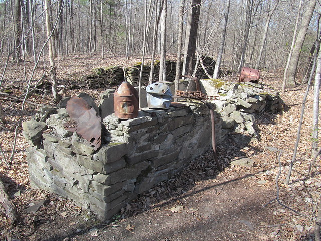
What wan't Harriman's preserve was Harriman's industrial wasteland - wrecked by mining and clearcutting. He had a lot of tenants who were driven out by the gift. He'd owned the hamlets of Johnsontown and Sandyfield outright, and they became ghost towns overnight. The ghost towns and abandoned mines are the reason that bushwhacking isn't allowed in Harriman - too much chance of people falling down abandoned wells and mineshafts, impaling themselves on decaying machinery, and similar man-made hazards. The gravel washer by Island Pond is one of the smaller bits of industrial archaeology to be found there.
AnotherKevin wrote:
You do realize that much of Harriman Park (and Bear Mountain as well) was E.H.Harriman's private preserve? The Elk Pen was where he kept captive elk, so that every fall he could let a few out and go hunting for them. His widow gave the acreage to the state on the condition that they not build a prison at Bear Mountain - she didn't want it that close to her place. They built it at Beacon instead.Trillium wrote:
Every single time that you Yankees mention Harriman Park, I am transported back to my high school days and think first of that railroad worker saying "I work for Mr. EH Harriman of the Union Pacific Railroad, and he entrusted me....." and the second thought is about the young guy I was sweet on and his buddy. That summer, the buddy was Butch, the young guy was The Kid and I was the Teacher Lady. We were going to the National Junior Achievement Convention in Bloomington, Indiana. Brings a smile to my face every time.
What wan't Harriman's preserve was Harriman's industrial wasteland - wrecked by mining and clearcutting. He had a lot of tenants who were driven out by the gift. He'd owned the hamlets of Johnsontown and Sandyfield outright, and they became ghost towns overnight. The ghost towns and abandoned mines are the reason that bushwhacking isn't allowed in Harriman - too much chance of people falling down abandoned wells and mineshafts, impaling themselves on decaying machinery, and similar man-made hazards. The gravel washer by Island Pond is one of the smaller bits of industrial archaeology to be found there.
along the trail there are 4 large wood observation decks (really nice!) and the self proclaimed "best privy in the woods". The post was edited 4 times, last by max.patch ().